
Article content
“The combination of intelligent infrastructure, IoT networks and data technologies provided the Department of Regional Development, Manufacturing, and Water with the capability to efficiently collect, transform, store, and more securely share water data across all levels of industry to make better data-driven decisions.”
Julian Butler Product Owner, Products & Technology, Telstra
The Department of Regional Development, Manufacturing and Water (RDMW) thinks ahead when it comes to managing Queensland’s land, water, mineral, and energy resources. New digital initiatives are essential in its drive to improve insights, efficiency and costs.
RDMW had previously partnered with Telstra to test a water quality monitoring system that combined innovative sensors with Telstra’s remote telemetry network to measure water quality across bores and rivers in the Lower Burdekin Region.
The next technology challenge RDMW considered was remote monitoring of river flows and height, crucial factors in managing the state’s water resources and also for predicting and managing floods.
Telstra, Photrack and SEBA Hydrometrie were awarded a tender to deliver a Proof of Concept (PoC) for a digital Contactless Water Flow Monitoring system for RDMW. The PoC would test both technical design and applicability to roll out across water bodies in Queensland.
Situation
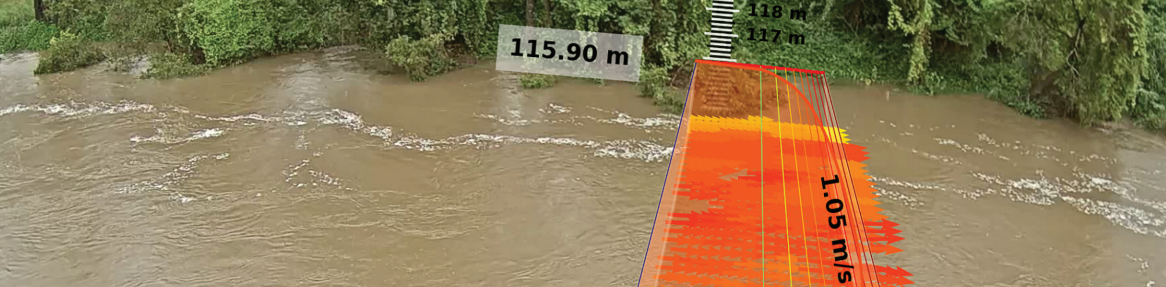
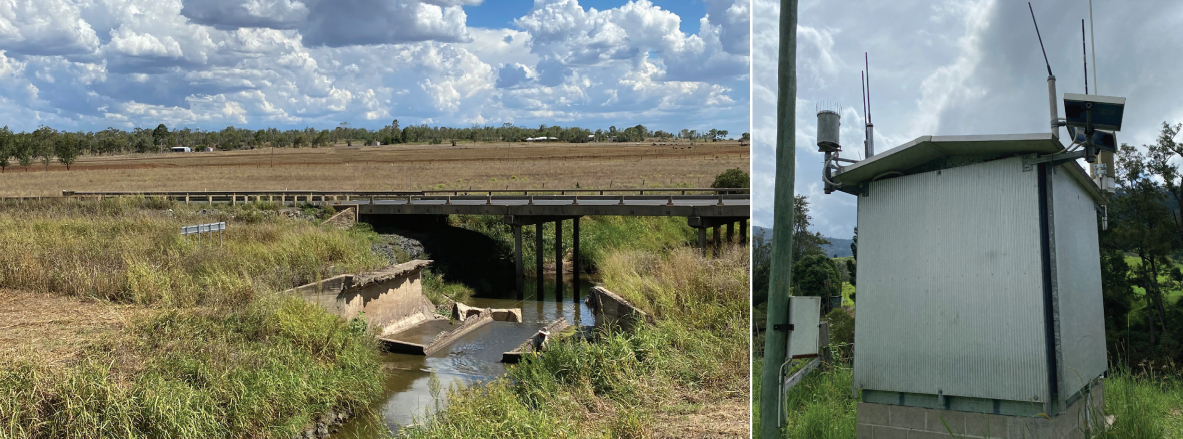
Current flow monitoring methods use physical measuring markers and level sensors on the riverbank. New methods of real-time flow measurement use various Image Velocimetry techniques where a fixed camera records river footage, and the velocimetry algorithm measures water height and velocity, computes discharge and generates a proof image.
Camera footage is generally stored on the remote site, then transferred over time to permanent storage. This is done in near real time via 4G where networks are available, or manually through physical site access. Data is then available to hydrographers to process on various desktop tools and databases.
However, network limitations restrict the transfer of data, and physical access is intermittent and time-consuming. So delays often occur between data collection and analysis. This limits effectiveness when near-real time reaction is required by RDMW, such as during floods or other dangerous weather events.
Information sharing and analysis across multiple tools and databases is also difficult. With no central point of data storage and access, cross-agency collaboration and planning are hampered.
RDMW commissioned the PoC to see if newer technology could reduce the time, cost and resources of data collection, while providing faster, more comprehensive analysis.
Solution
Telstra’s end-to-end solution combined commodity hardware on the edge, more secure network access, and advanced software algorithms both on the edge and in the cloud for image processing. In addition, data acquisition, analytics and sharing were done in the cloud via the Telstra Data Hub.
For sites with strong network coverage, Telstra used hardware on site that comprised a standard IP camera and an industrial router to capture videos and images. Excerpts of that data were sent over Telstra’s LTE-M network to be processed in the cloud.
For sites where network coverage was challenging, an industrial-grade PC was connected to the camera. The PC’s software would process the videos on site and send only control images and measurement results data to the Telstra Data Hub. In both cases, all data remained encrypted throughout the process.
For the software, Telstra turned to Photrack AG and SEBA Hydrometrie who are leaders in water flow measurement. The Photrack AG team provided sophisticated algorithms to analyse water levels, surface flow velocities, and discharge through the Discharge software suite:
DischargeKeeper. DischargeKeeper software can be deployed on site or in the cloud to optically measure water discharge from IP surveillance cameras. It runs autonomously after the initial set up.
Surface velocity is measured through Surface Structure Image Velocimetry (SSIV), a patented algorithm based on a cross-correlation technique. Water level detection is done simultaneously by image processing.
DischargeLab. DischargeLab is a fully configurable application that receives and collates videos and data from compatible sources to calculate detailed 2D surface velocities, water level and discharge.
For more secure data storage, compute, permissioning and sharing of data, the team used the Telstra Data Hub.
The Telstra Data Hub also provides more advanced data science tools for further analysis of the data, with the ability to layer multiple data sets together to gain rich, contextual insights. Backed by the power of the Microsoft Azure cloud, the Telstra Data Hub can also quickly scale to meet intensive compute or storage demands.
Additionally, the Telstra Data Hub is hosted locally in Australia to help ensure data sovereignty, while multiple security measures help protect data at every stage.
Safe sharing of data is a key advantage of the Telstra Data Hub. Data owners decide what to share, with whom, and for what purpose. Permissions can be set at a granular level for specific data points, not the entire data set, giving both data owners and data consumers more flexibility. In addition, all data is catalogued for fast search and retrieval.
The combination of Discharge’s software and the Telstra Data Hub creates a powerful synergy, says Salvador Peña, the CTO of Photrack:
“The integration between Telstra Data Hub and the image based technology, DischargeKeeper, opens new horizons, from having contactless sensors which measure the discharge and provide proof images, to adding value to the collected measurements via data analysis and safe data sharing.” Salvador Peña CTO of Photrack
Results
The initial outcomes from the PoC validated a number of RDMW’s requirements. However, fine-tuning of the solution would be needed for a roll-out at mass scale in Queensland, given the variety of water bodies in the state.
These included better defining minimum site standards, tighter integration of solution elements, improving measurement accuracy at challenging sites, and simplifying visualisation tools for hydrographers in the field. The solution would also need to be commoditised to be cost-effective.
Nevertheless, the PoC clearly demonstrated the potential of contactless water flow monitoring to be the next generation of remote, real-time monitoring of water bodies.
Deployment and maintenance
The PoC provided a low-touch solution that required limited maintenance beyond the initial set up.
Once configured for the surrounding environment, cameras did not need water level sensors on the riverbank, except in areas with heavy riverside vegetation. Level sensors are also prone to damage or loss from floodwaters, so avoiding their use reduces manual replacement costs.
In addition, remote telemetry removed the need for manual collection of data, which is often too slow and inefficient for real-time data analysis.
Together, both factors significantly cut the time and cost of labour. Equally important, the environmental impact of excursions into remote areas would be reduced.
Worker safety would also be improved by reducing trips to these areas. Furthermore, staff could gather key measurements for generating the streamflow rating without the additional risk of launching a boat into floodwaters as with conventional measurement.
Remote coverage
The ability to process data at the edge with industrial PCs provided access in very remote areas in a cost effective way. As large video files aren’t sent to the cloud, only outputs of the processed data, low bandwidth LTE-M or NB-IoT wireless networks would suffice.
Sites that weren’t as remote could use Telstra’s high capacity 4G and 5G to send both data and images.
Where wireless networks don’t reach, satellite telemetry could be a viable alternative. Lower data quantities would also reduce the cost of satellite communications.
Timeliness and response
The flow of information from the camera to collation showed dramatic improvement. Previously, data could take days or weeks to be sent for analysis. Compare that to results typically being available every 30 minutes with the PoC. The time interval could be even shorter if desired.
This offers crucial advantages for response to river events. For example, hydrologists could predict flooding long before water levels posed a threat to the surrounding community, and warnings could be sent early to reduce damage, loss of life and prepare Emergency Services.
Conversely, the solution could be used to forewarn of reduced water flows and possible droughts. Using predictive modelling, hydrologists could measure the potential severity of a drought to support water conservation and allocation to areas that need it most.
Analysis and sharing
Centralising data collection, analysis, and sharing via the Telstra Data Hub opened up a wealth of possibilities.
Instead of multiple databases, information would be in one place. Powerful tools, either built in or supplied by RDMW, would allow users to drill-down, extrapolate and visualise data in ways that may not be feasible today. And they would be supported by AI and ML across massive data sets to help deliver better results faster.
Furthermore, data could be accessed by a broader data community and integrated with more comprehensive data sets, both inside and outside RDMW. This would lead to greater collaboration and understanding.
In short, the PoC demonstrated that data sent in near real time could be accessed more easily by more people. At the same time, powerful, standardised tools would improve data sharing and analysis. This could deliver breakthrough insights on river events - and new ways to manage them.
These are significant advantages that would justify further investigation, says Arran Corbett, Project Manager – Enhanced Measurement, of RDMW:
“In conclusion, the project team believes that we have achieved significant learnings in this emerging field and have positioned the Queensland Government in a leading role. Further efforts will continue, based on RDMW standardised hardware packages, to develop the embedded solutions in evolving systems environment and verification of emerging algorithms.” Arran Corbett Project Manager, Enhanced Measurement RDMW
In essence, this PoC and others like it are just the start of the journey. Digital and Big Data are the future. To prepare for the future, RDMW understands the first steps have to be taken now.
Download PDF of case study here.
